Su - Lokakuu 23, 2005
Planning for the trip and testing tools.
Planning for the trip, route
map
Three days to go. Spent the weekend playing with
mapping software and creating a coarse plan. Might have some company business in
Pittsburgh first. I enjoy single malts so visiting some Bourbon distillers in
Kentucky sounds like a good idea. The mountains in Colorado / Utah / Nevada
looks good in pictures so I want to check them out. Have to be in Milpitas, CA
on Sunday, Nov 13th to attend some compnay business next week there. Everything
else is open.
Note: Red line rough plan, blue line is the real route so far (will be updated now and then)
More & full sized pictures can be found here.
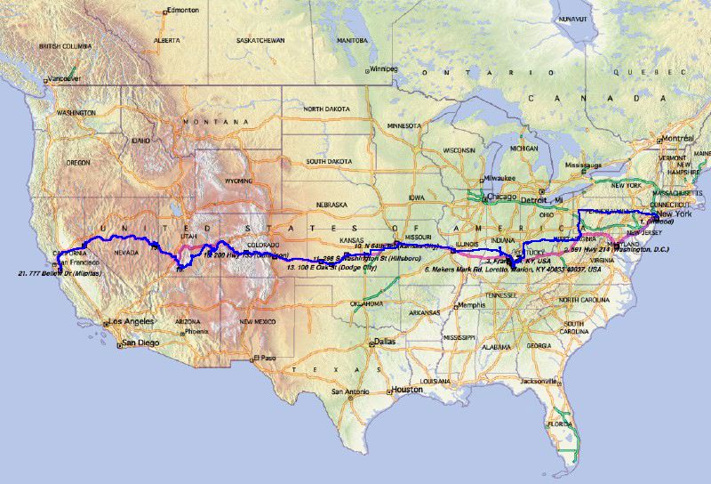
Route plan (red) and real route (blue)
Note: Red line rough plan, blue line is the real route so far (will be updated now and then)
More & full sized pictures can be found here.
Route plan (red) and real route (blue)
Posted at 07:43 ip.
Pe - Lokakuu 28, 2005
First 500 miles
Arrived New York, got a car and headed to
Pittsburgh for some company business.
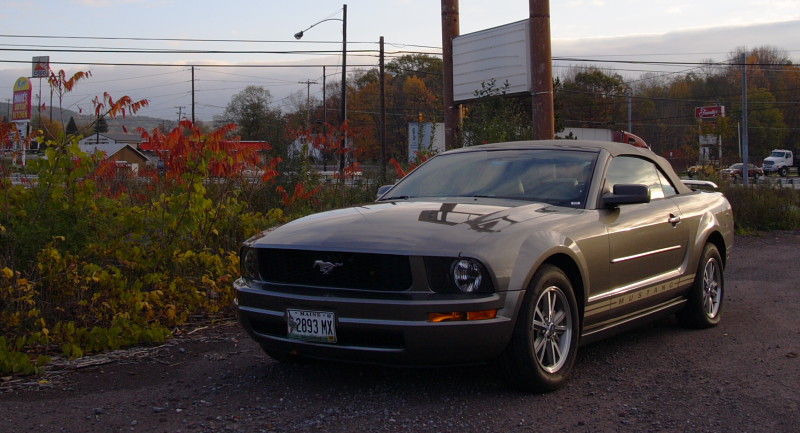
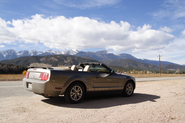
Hertz decided to gave me Mustang convertible for
my pan-US trip. Normally I would have been delighted to have a convertible but
winter is close and I wonder how the car will be in Colorado Rockies.. Maybe I
have to select more southern route after all. I wonder if Hertz see more demand
for convertibles in California than in New York and wants me to move the car
there.
It's relatively good to drive, though, and quieter than I thought it would be. I just hope it's not too thirsty, as gas is no more free here:
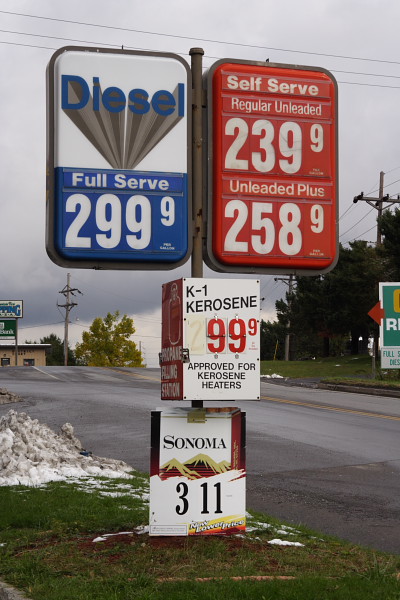
I had a meeting near Pittsburgh in thursday afternoon so the first 500 miles or so went very quickly. - after I found my way out from New York - that is. I'm using digital maps mostly and found out that the software did not work very well with GPS.
From now on I should be able to drive smaller roads and spend less time driving.
It's relatively good to drive, though, and quieter than I thought it would be. I just hope it's not too thirsty, as gas is no more free here:
I had a meeting near Pittsburgh in thursday afternoon so the first 500 miles or so went very quickly. - after I found my way out from New York - that is. I'm using digital maps mostly and found out that the software did not work very well with GPS.
From now on I should be able to drive smaller roads and spend less time driving.
Posted at 04:14 ap.
La - Lokakuu 29, 2005
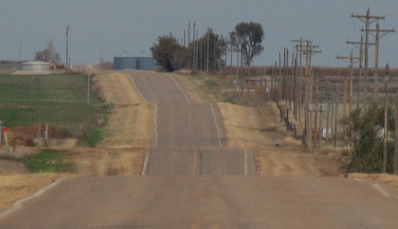
US-50: West Virginia, Ohio
Left the busy interstates and started following
US-50 through West Virginia and Ohio. Rusty old industrial cities, fall colours,
quiet roads.
My plan is still to follow loosely US-50 unless
it looks like I have to cross rocky mountains through a more southern route (I'm
sure the big roads would be fine but I want to check some smaller roads,
too).
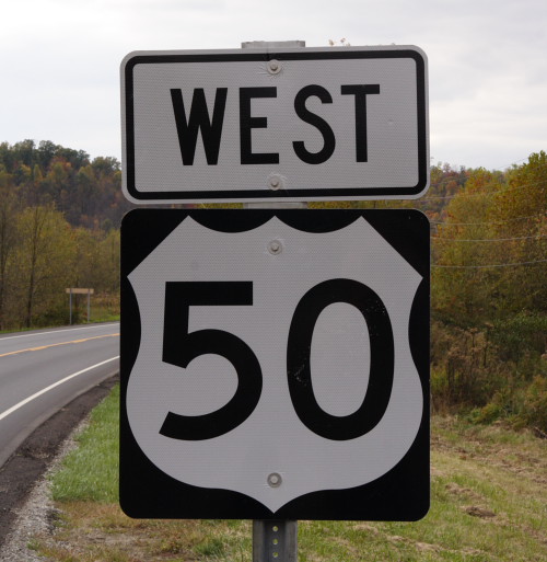
I entered US-50 at Clarksburg, an old railroad town close to IS-79. The town has a nice old commercial area with old decaying buildings from the turn-of-the-century (1900..).
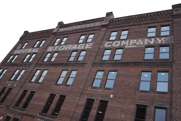
I still cannot get business out of my mind (being in storage business..)
Long time ago in a place far away..
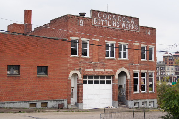
Was last time open for business about 50 years ago, I think.
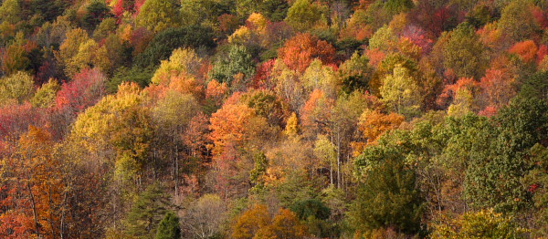
I'm driving through the states during the best time for fall colours.
I entered US-50 at Clarksburg, an old railroad town close to IS-79. The town has a nice old commercial area with old decaying buildings from the turn-of-the-century (1900..).
I still cannot get business out of my mind (being in storage business..)
Long time ago in a place far away..
Was last time open for business about 50 years ago, I think.
I'm driving through the states during the best time for fall colours.
Posted at 04:08 ip.
Su - Lokakuu 30, 2005
Cinnicati.. Cincicati.. CINCINNATI!
Started the day visiting Cincinnati. Then a quick
drive south to start Bourbon whisky trail in Kentucky.
The day started frosty. I'm almost 2500 Km south
from Helsinki and the nights are colder here! My hotel was near Cincinnati so I
headed there for breakfast. It took some time to learn spell it right..
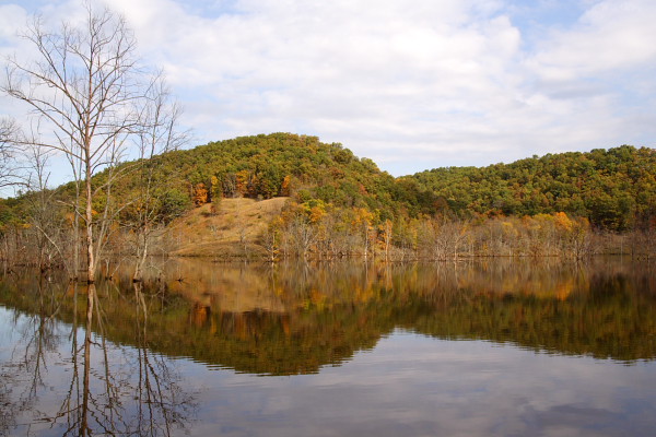
Cincinnati was a important gateway to river Ohio and Mississippi in the old days
but today very little from that is left. The northern side is ugly commercial
city with high modern buildings and the river bank has been completely destroyed
with two huge stadiums. The southern part is slightly better and some of the old
buildings remain. Some of the old river boats are there as cruise boats or
restaurants.
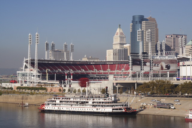
Stadium and downtown buildings.
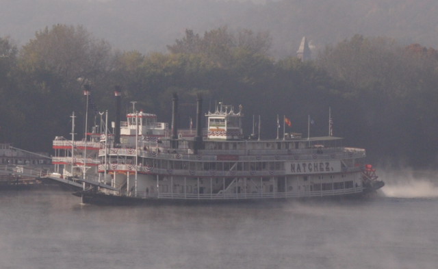
River boat departing for a cruise. River Ohio is steaming in the cold morning.
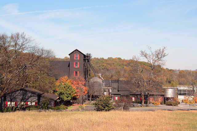
After Cincinnati I headed south to start Bourbon whisky trail in Kentucky. It was saturday afternoon and I was too late for Buffalo Trace distillery - the last tour was an hour ago. Next step was Four Roses where I caught the last tour of the day. Four Roses is one of the older distilleries and the buildings and machinery shows that - which is nice. I sampled some single cask whisky and it was quite good if not at the same level as good Single Malt. On Sunday I plan to visit Heaven Hill and Maker's Mark.
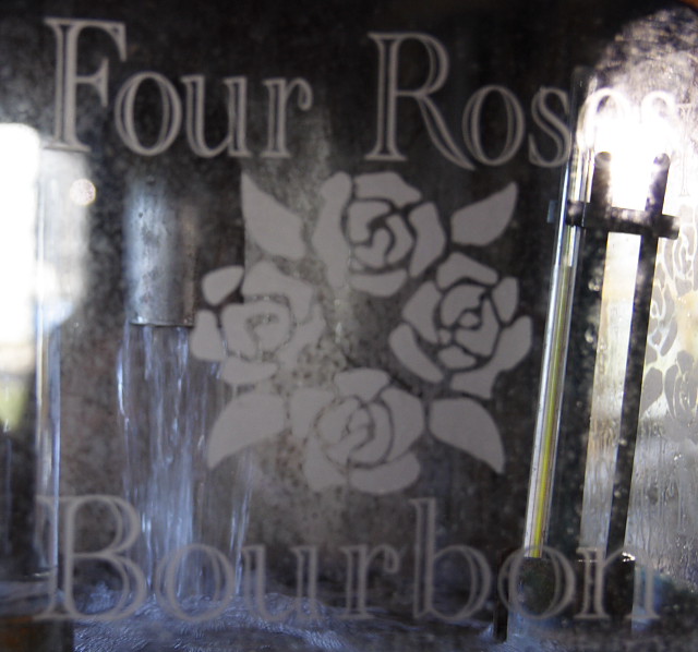
Kentucky Straight Bourbon flowing from the still.
Finding cheap hotels in late October is easy - most of the roadside hotels are half empty. Unfortunately I manage almost always to attract very noisy people to the next room and the noise insulation is non-existent in these hotels.
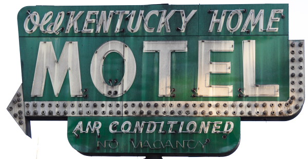
My home in Bardstown.
Cheap hotels do not offer internet access to rooms so I'm now visiting Starbucks to stay connected. I never understood the idea of using laptops in cafe's but now I do. Maybe it has something to do with the fact that GSM/GPRS works here worse than in Iceland, for example..
Driving in the eastern states is more aggressive than what I'm used to in California. Especially the big interstate roads are bad - they are full of trucks and the trucks drive as fast as they can. I usually set cruise control to 70-75 mph. The big trucks often overtake me in downhills (they go more than 80 mph) but cannot keep that speed in uphill so I have to overtake them and then it starts again. Fortunately I have reasonable agile car so I can out run the (other) maniacs on the road.
Stadium and downtown buildings.
River boat departing for a cruise. River Ohio is steaming in the cold morning.
After Cincinnati I headed south to start Bourbon whisky trail in Kentucky. It was saturday afternoon and I was too late for Buffalo Trace distillery - the last tour was an hour ago. Next step was Four Roses where I caught the last tour of the day. Four Roses is one of the older distilleries and the buildings and machinery shows that - which is nice. I sampled some single cask whisky and it was quite good if not at the same level as good Single Malt. On Sunday I plan to visit Heaven Hill and Maker's Mark.
Kentucky Straight Bourbon flowing from the still.
Finding cheap hotels in late October is easy - most of the roadside hotels are half empty. Unfortunately I manage almost always to attract very noisy people to the next room and the noise insulation is non-existent in these hotels.
My home in Bardstown.
Cheap hotels do not offer internet access to rooms so I'm now visiting Starbucks to stay connected. I never understood the idea of using laptops in cafe's but now I do. Maybe it has something to do with the fact that GSM/GPRS works here worse than in Iceland, for example..
Driving in the eastern states is more aggressive than what I'm used to in California. Especially the big interstate roads are bad - they are full of trucks and the trucks drive as fast as they can. I usually set cruise control to 70-75 mph. The big trucks often overtake me in downhills (they go more than 80 mph) but cannot keep that speed in uphill so I have to overtake them and then it starts again. Fortunately I have reasonable agile car so I can out run the (other) maniacs on the road.
Posted at 03:01 ap.
Ti - Marraskuu 1, 2005
Bourbon trail, Louisville and St. Louis
Bourbon whisky trail did not succeed very well
due to bad timing. Went to Louisville and found out that the whole city is
closed on Sundays. Continued next day to St. Louis and made a side trip to
Marengo caverns.
I planned to visit two distillers on Sunday,
Heaven Hills and Maker's Mark. Heaven Hill opened at 12:00 and Maker's Mark at
13:30. While spending the morning in my hotel I learned that there are some
interesting caves near Louisville so I decided to tighten my schedule a bit.
Maker's Mark was some 20 miles to the opposite direction from my route so I
decided go there in the morning to see it from outside and then pick up Heaven
Hills on my vay to Louisville. After a nice drive through Kentucky country side
I arrived to Maker's Mark and found out that the setting was
perfect:
The distillery is hidden in the middle of nowhere in it is easy to imagine that long time ago moonshine was produced there and later expanded to a legal business. Definately a place worth visiting and I started regretting my decision so skip the tour.
The next stop was Heaven Hills - unfortunately the visitors center was closed for inventory so that ended my whisky tour - one distillery visited inside.
I continued to Louisville in hope to find some city life. I took some time even to find downtown! I drove around empty streets and blocks and finally realized that this is the downtown! I have never seen so deserted downtown area - no people, no cars and many blocks were empty from buildings. No shops, either, and the few restaurants were mostly closed. Never go to Louisville on Sundays! While driving around the city I noticed this funny little baseball bat:
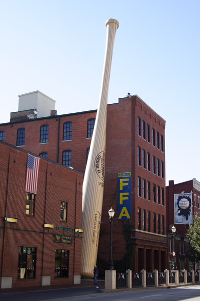
120 feet long "Louisville Slugger"
The next day I left early as I had long drive and planned a side trip to Bluesprings Caverns. The earliest tour would have been at 12:00 so I went to nearby Marengo Caverns and took two tours there. Indiana is full of holes, it seems.
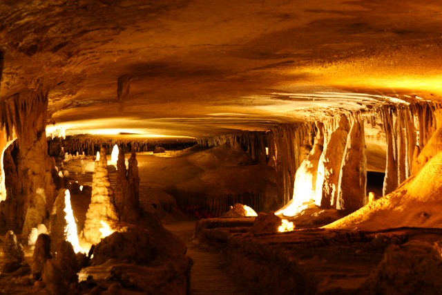
Marengo caves
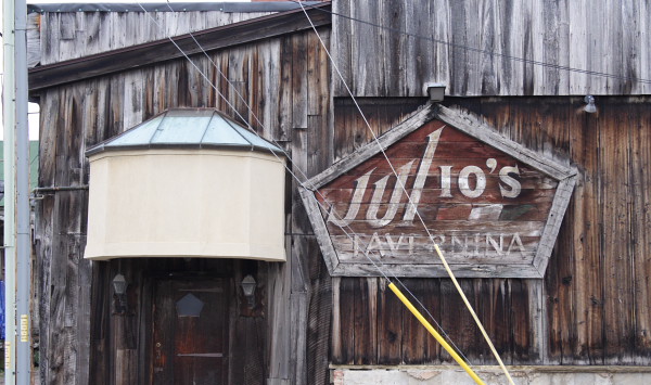
I loosely followed US-50 and other small roads between Louisville and St. Louis. In US, one can expect some surprising things when travelling those small roads, like this one:
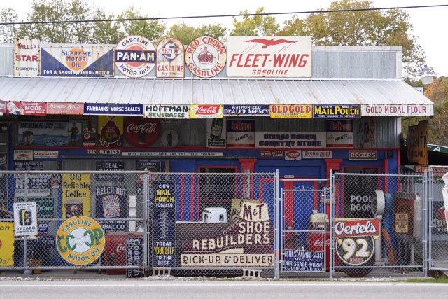
Old signs in a small village somewhere in Indiana
St. Louis looks like an interesting city, but it was monday, raining heavily and Halloween night so downtown was pretty quiet.
The distillery is hidden in the middle of nowhere in it is easy to imagine that long time ago moonshine was produced there and later expanded to a legal business. Definately a place worth visiting and I started regretting my decision so skip the tour.
The next stop was Heaven Hills - unfortunately the visitors center was closed for inventory so that ended my whisky tour - one distillery visited inside.
I continued to Louisville in hope to find some city life. I took some time even to find downtown! I drove around empty streets and blocks and finally realized that this is the downtown! I have never seen so deserted downtown area - no people, no cars and many blocks were empty from buildings. No shops, either, and the few restaurants were mostly closed. Never go to Louisville on Sundays! While driving around the city I noticed this funny little baseball bat:
120 feet long "Louisville Slugger"
The next day I left early as I had long drive and planned a side trip to Bluesprings Caverns. The earliest tour would have been at 12:00 so I went to nearby Marengo Caverns and took two tours there. Indiana is full of holes, it seems.
Marengo caves
I loosely followed US-50 and other small roads between Louisville and St. Louis. In US, one can expect some surprising things when travelling those small roads, like this one:
Old signs in a small village somewhere in Indiana
St. Louis looks like an interesting city, but it was monday, raining heavily and Halloween night so downtown was pretty quiet.
Posted at 03:32 ip.
To - Marraskuu 3, 2005
St. Louis, Kansas City and Kansas
Spent a morning in a sunny St. Louis, took then
quick road to Kansas City. The next day started following US-56 through
Kansas.
Tuesday morning was nice and sunny in St. Louis
so I walked around a little. Downtown was now alive but in sunshine it looked
mostly like any big business district - boring. Darkness and rain had made it
look much more sinister and interesting in the previous evening. Still there was
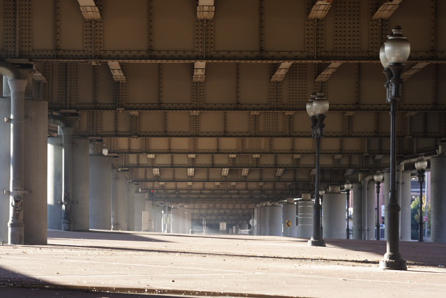
some similarities to my favourite US city - Chicago. For example, my route from
the hotel to downtown went under raised I-70 road which reminds me the raised
roads and tracks in Chicago.
I did not have time to search for more interesting areas so I headed to Mississippi river front. This area is dominated by a huge arch. The building has very simple, clean design but it's sheer size makes it really impressive. Too impressive for my camera, actually - I should have gone to the other side of Mississippi to get a good picture.
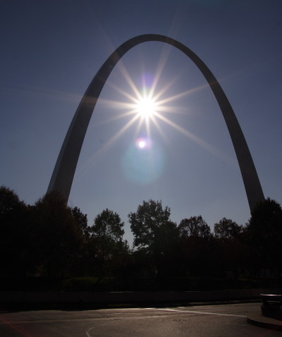
St. Louis Arch: Bigger than Sun..
I followed the river back to my hotel and realized that my hotel was between the downtown business area and an old, deteriorated industrial area. I just love those those old brick buildings and the mood and how nature is claiming back those areas.
Next destination was Kansas City. I decided to save some time so I took interstate 70 instead of smaller roads and drove about 240 miles without too many interruptions. In Kansas City I decided to check only one area and then go on as I needed to hurry up and save some time for mountains next week. I went to West Port area as my guide book said it is the birthplace of the city. I was not exactly expecting to find Wild West there but Kansas City managed to surprise me quite completely. The area was quite hippy, full of cafe's and ethnic restaurants. Classic music was playing from loudspeakers in street corners. I went to a brew pub for a good IPA and read the local news paper - found out it was quite liberal paper. Having driven through the "bible belt" this was quite refreshing.
The final surprise happened in a liquor store - I was running out of my travel beer (Sierra Nevada Pale Ale) and figured out West Port would be good place to find more. They had Sierra Nevada there and lots of other good labels as well. They had also small but interesting selection on Single Malts, including some 30 years old Bowmore. It is excellent stuff but very expensive and hard to find. There they had 5 bottles at half of the normal price! Too bad I could bring all of them back home.
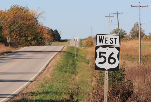
On Wednesday I started following US-56 (sometimes called US-50 north) which follows quite closely the old Santa Fe trail used in late 1800's. This area is almost completely flat, endless fields and straight roads. Not too much to see unless one wants to study the history of Santa Fe road. Still, it was nice relaxing drive and there are some nice old towns on the way.
I stopped a few times to see some of the old towns and there was also a wildlife refugee with some buffalos roaming (or actually they were staying close to ranger station and eating hay - not very impressive..).
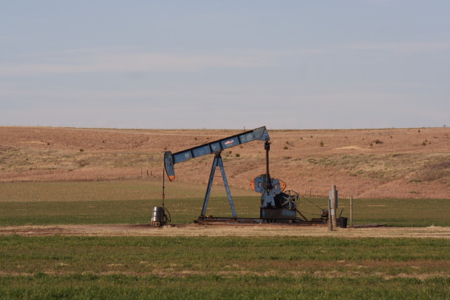
Drilling oil seems to be a popular local hobby - small pumps could be seen everywhere
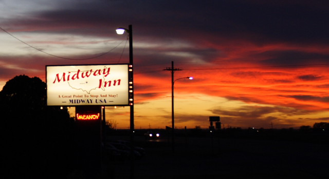
Darkness comes early at this time of year and I don't want to drive in dark unless needed so I stopped at a small town which claims being exactly in the middle between New York and San Francisco. Too bad the hotel I found is between the US-50/US-56 intersection and railways tracks - not exactly a quiet place..
I did not have time to search for more interesting areas so I headed to Mississippi river front. This area is dominated by a huge arch. The building has very simple, clean design but it's sheer size makes it really impressive. Too impressive for my camera, actually - I should have gone to the other side of Mississippi to get a good picture.
St. Louis Arch: Bigger than Sun..
I followed the river back to my hotel and realized that my hotel was between the downtown business area and an old, deteriorated industrial area. I just love those those old brick buildings and the mood and how nature is claiming back those areas.
Next destination was Kansas City. I decided to save some time so I took interstate 70 instead of smaller roads and drove about 240 miles without too many interruptions. In Kansas City I decided to check only one area and then go on as I needed to hurry up and save some time for mountains next week. I went to West Port area as my guide book said it is the birthplace of the city. I was not exactly expecting to find Wild West there but Kansas City managed to surprise me quite completely. The area was quite hippy, full of cafe's and ethnic restaurants. Classic music was playing from loudspeakers in street corners. I went to a brew pub for a good IPA and read the local news paper - found out it was quite liberal paper. Having driven through the "bible belt" this was quite refreshing.
The final surprise happened in a liquor store - I was running out of my travel beer (Sierra Nevada Pale Ale) and figured out West Port would be good place to find more. They had Sierra Nevada there and lots of other good labels as well. They had also small but interesting selection on Single Malts, including some 30 years old Bowmore. It is excellent stuff but very expensive and hard to find. There they had 5 bottles at half of the normal price! Too bad I could bring all of them back home.
On Wednesday I started following US-56 (sometimes called US-50 north) which follows quite closely the old Santa Fe trail used in late 1800's. This area is almost completely flat, endless fields and straight roads. Not too much to see unless one wants to study the history of Santa Fe road. Still, it was nice relaxing drive and there are some nice old towns on the way.
I stopped a few times to see some of the old towns and there was also a wildlife refugee with some buffalos roaming (or actually they were staying close to ranger station and eating hay - not very impressive..).
Drilling oil seems to be a popular local hobby - small pumps could be seen everywhere
Darkness comes early at this time of year and I don't want to drive in dark unless needed so I stopped at a small town which claims being exactly in the middle between New York and San Francisco. Too bad the hotel I found is between the US-50/US-56 intersection and railways tracks - not exactly a quiet place..
Posted at 05:49 ap.
Pe - Marraskuu 4, 2005
Flatland
Drove through the fields in flat Kansas and
arrived to Colorado
Kansas is part of the US "Wheat belt" - endless
fields and straight roads. The eastern Kansas has some hills and was nice to
drive through but western part is just flat and boring.
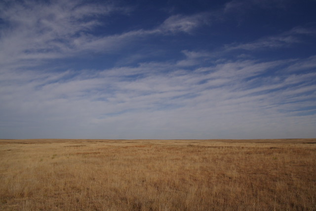
Kansas landscape
US-50 through Kansas
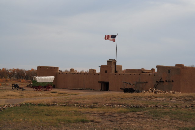
The road follows the old Santa Fe track and there are some old Military Forts which can be visited. The one I visited inside (Bent's) was not actually a military fort but more like trading post but also used for defense. It was restored in 70's and is in good condition and interesting place to visit.
Like in "Lucky Luke" albums
I'm quickly learning the budget hotel code in US. For example, "Motel 6" has usually good rates, clean rooms but no other services (like breakfast, internet connection) and the locations are outside of cities along highways. One of my favourite chains, though. "Econo lodge" is another budget chain but they have also hotels in or near downtown areas. The cheap downtown hotels are often not too shabby but still ok. "Comfort Inn" has higher prices but they offer reasonable breakfast (cereals, bread etc) and often free wireless internet. Rooms can be very nice for the price. Often good price/value. "Hampton Inn" is even more expensive chain and to me it does not offer any extra value over "Comfort Inn", for example.
The "Mom & Pa" hotels can be anything from nice surprises to ugly places. Usually the prices are low and hotels can be found in areas where big chains do not go.
Kansas landscape
US-50 through Kansas
The road follows the old Santa Fe track and there are some old Military Forts which can be visited. The one I visited inside (Bent's) was not actually a military fort but more like trading post but also used for defense. It was restored in 70's and is in good condition and interesting place to visit.
Like in "Lucky Luke" albums
I'm quickly learning the budget hotel code in US. For example, "Motel 6" has usually good rates, clean rooms but no other services (like breakfast, internet connection) and the locations are outside of cities along highways. One of my favourite chains, though. "Econo lodge" is another budget chain but they have also hotels in or near downtown areas. The cheap downtown hotels are often not too shabby but still ok. "Comfort Inn" has higher prices but they offer reasonable breakfast (cereals, bread etc) and often free wireless internet. Rooms can be very nice for the price. Often good price/value. "Hampton Inn" is even more expensive chain and to me it does not offer any extra value over "Comfort Inn", for example.
The "Mom & Pa" hotels can be anything from nice surprises to ugly places. Usually the prices are low and hotels can be found in areas where big chains do not go.
Posted at 06:29 ap.
Su - Marraskuu 6, 2005
Colorado
Arrived to Colorado and spent some time in
mountain area.
Colorado started like Kansas - flat. The first
towns and roads also looked poorer than in Kansas. Things started change when I
came nearer to mountains and finally reached El Pueblo - the first larger town
since Kansas City.
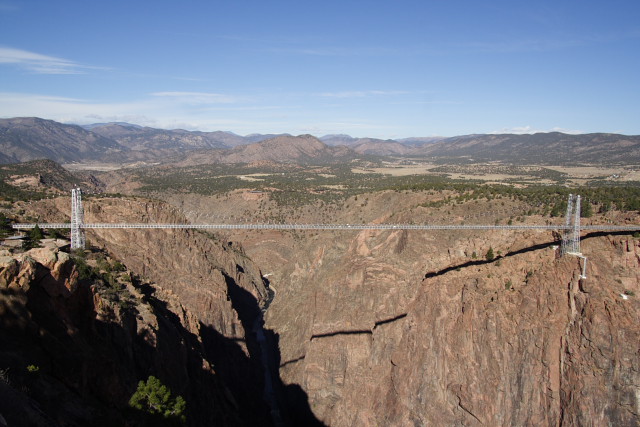
Next morning I started exploring the mountain attractions in Colorado. First step was Royal Gorge bridge near Canon. The bridge is claimed to be the highest suspension bridge (1053 feet to river Arkansas) in the world and is today only a tourist attraction - the heavy traffic goes elsewhere. The bridge itself is very old (but reworked in 80's) and narrow and unsuitable for heavy car traffic. I decided to walk over the bridge. Being a suspension bridge one can feel how the bridge moves because of winds or cars driving over the bridge - not a nice feeling when there is 300m drop..
Royal Gorge
So far I had kept the roof of my car up - in eastern states it was too cold to take the top down and in middle states I just wanted to keep good pace and there was nothing to see above horizont, anyway. Things changed in Colorado - the weather was surprisingly warm and I was ahead of my plans so I took the top down and drove US-50 lazily enjoying the scenery. After 30 minutes or so I had to stop and raise the roof as I did not have any sunblock and started feeling the effects of sun in high altitudes. The road also started to climb to over 3000 meters altitude and it was not so warm anymore.
Finally!
My next destination was Black Canyon but first I needed to adjust to the high altitudes (~2500 meters) a bit and stopped at Gunnison for one night. US used to be very bad place for beer lovers but things have changed dramatically. While Bud & Miller still rules the markets there are lots of microbreweries everywhere and even Gunnison had its own brewpub. Their IPA was pretty good and they had very good quest beer (a winter beer from "Avery" brewery or something like that) on tap.
The next morning started with some snowfall but fortunately Black Canyon escaped the snowfall this time and weather was very good there. Black Canyon is rather awesome deep, narrow canyon. The highest walls are almost 1000 meters high and almost vertical and some of the view points were on those cliffs! Trying to take a good photograph from that place was too much for my skills - especially under the harsh midday sun. This one gives some kind of idea, though:
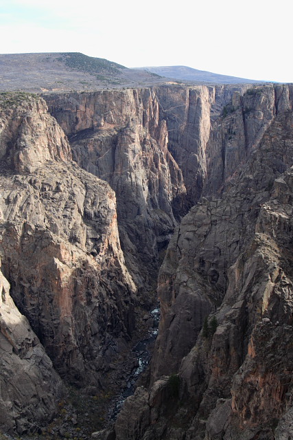
Black Canyon
I was still ahead of my plans so I decided to take a hotel in nearby town Montrose and come back to the park later in the afternoon. Unfortunately it was mostly cloudy and the name Black Canyon comes anyway from the fact the bottom of the canyon is pretty dark even at noon and evening light has no chance to enter the canyon. Still the sunset was pretty nice and some sun rays escaped the clouds giving the canyon rim some nice colors.
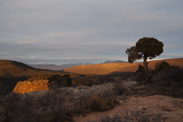
Dusk at Black Canyon
Next morning I started exploring the mountain attractions in Colorado. First step was Royal Gorge bridge near Canon. The bridge is claimed to be the highest suspension bridge (1053 feet to river Arkansas) in the world and is today only a tourist attraction - the heavy traffic goes elsewhere. The bridge itself is very old (but reworked in 80's) and narrow and unsuitable for heavy car traffic. I decided to walk over the bridge. Being a suspension bridge one can feel how the bridge moves because of winds or cars driving over the bridge - not a nice feeling when there is 300m drop..
Royal Gorge
So far I had kept the roof of my car up - in eastern states it was too cold to take the top down and in middle states I just wanted to keep good pace and there was nothing to see above horizont, anyway. Things changed in Colorado - the weather was surprisingly warm and I was ahead of my plans so I took the top down and drove US-50 lazily enjoying the scenery. After 30 minutes or so I had to stop and raise the roof as I did not have any sunblock and started feeling the effects of sun in high altitudes. The road also started to climb to over 3000 meters altitude and it was not so warm anymore.
Finally!
My next destination was Black Canyon but first I needed to adjust to the high altitudes (~2500 meters) a bit and stopped at Gunnison for one night. US used to be very bad place for beer lovers but things have changed dramatically. While Bud & Miller still rules the markets there are lots of microbreweries everywhere and even Gunnison had its own brewpub. Their IPA was pretty good and they had very good quest beer (a winter beer from "Avery" brewery or something like that) on tap.
The next morning started with some snowfall but fortunately Black Canyon escaped the snowfall this time and weather was very good there. Black Canyon is rather awesome deep, narrow canyon. The highest walls are almost 1000 meters high and almost vertical and some of the view points were on those cliffs! Trying to take a good photograph from that place was too much for my skills - especially under the harsh midday sun. This one gives some kind of idea, though:
Black Canyon
I was still ahead of my plans so I decided to take a hotel in nearby town Montrose and come back to the park later in the afternoon. Unfortunately it was mostly cloudy and the name Black Canyon comes anyway from the fact the bottom of the canyon is pretty dark even at noon and evening light has no chance to enter the canyon. Still the sunset was pretty nice and some sun rays escaped the clouds giving the canyon rim some nice colors.
Dusk at Black Canyon
Posted at 06:59 ap.
Ke - Marraskuu 9, 2005
Red rock (Utah)
Continued my travels to Utah where I planned to
spend a few days exploring Arches, Canyonlands and Bryce Canyon
parks.
I drove through eastern and middle USA pretty
quickly as I really wanted to spend some time in the rocky mountains area,
especially in Utah. I have been in Colorado earlier so given my schedule I
decided to spend most of my time in Utah. After Black Canyon I had a travel day
to Moab. The distance was only about 300 Km so I stopped at Colorado monument
park to get first taste of the strange landscape that was waiting for me - red
rock in strange
shapes.
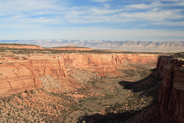
Canyon in Colorado monument park
After spending some time in the park I continued to Utah. For the first 50 miles there was nothing to see, no towns, no farms, just almost flat wasteland. The fastest route to Moab would have been to follow I-70 as long as possible but I decided to escape the boring interstate and took road 128. The road follows Colorado river for the last 10-20 miles to Moab and was just astonishing! The river has carved a deep winding canyon through the red rock and the road follows the river in the same canyon. Trees and bushes line the river in yellow fall colors. This time I was really happy Hertz gave me a convertible and cruised slowly to Moab top down.
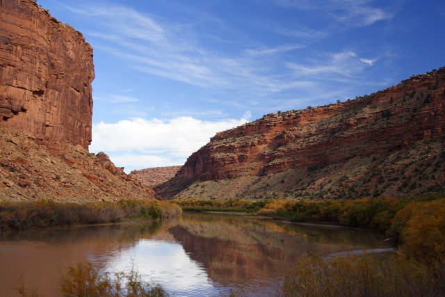
Colorado River and road 128 (Utah)
The next day I really started exploring Utah parks. First destination was Arches, best known from the "Delicate Arch", which is symbol for the whole state of Utah and is probably in every Western movie ever made.
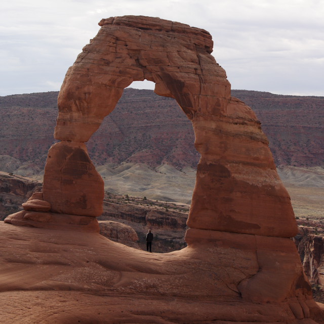
Delicate arch - Arches national park in Utah
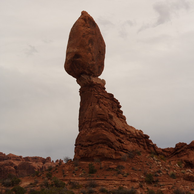
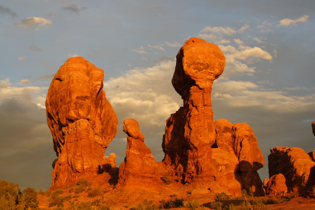
Balanced rock - another popular sight in Arches park
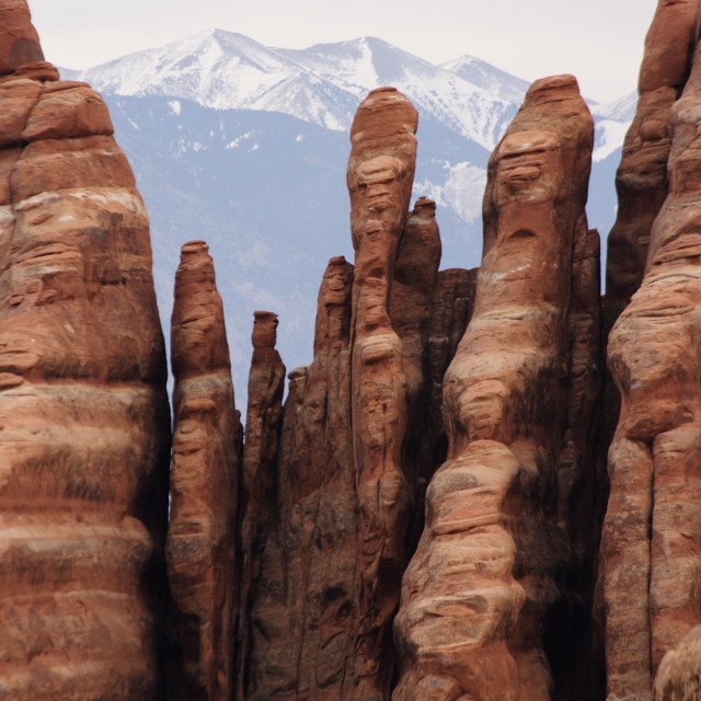
Arches gave me my first taste of the real strange formations and often mind starts playing tricks with the rocks - can you see the "faces" in the next picture?
After visiting Delicate Arch I took quite a long hike with several arch formations on the way and very nice about 5 miles long stretch down in the canyon and in the middle of the formations. The day was mostly cloudy but just before sunset the sky started getting clear and the setting sun colored everything with deep red hues. Look at the picture for some time - to me it looks like a some kind of "family" meeting..
Sunset - Arches park
Moab is the best home base for Arches and Canyonlands. It is a small mining town but today lives on tourism and has all the hotels and restaurants one needs. There are even two microbreweries serving very passable local beer.
Canyon in Colorado monument park
After spending some time in the park I continued to Utah. For the first 50 miles there was nothing to see, no towns, no farms, just almost flat wasteland. The fastest route to Moab would have been to follow I-70 as long as possible but I decided to escape the boring interstate and took road 128. The road follows Colorado river for the last 10-20 miles to Moab and was just astonishing! The river has carved a deep winding canyon through the red rock and the road follows the river in the same canyon. Trees and bushes line the river in yellow fall colors. This time I was really happy Hertz gave me a convertible and cruised slowly to Moab top down.
Colorado River and road 128 (Utah)
The next day I really started exploring Utah parks. First destination was Arches, best known from the "Delicate Arch", which is symbol for the whole state of Utah and is probably in every Western movie ever made.
Delicate arch - Arches national park in Utah
Balanced rock - another popular sight in Arches park
Arches gave me my first taste of the real strange formations and often mind starts playing tricks with the rocks - can you see the "faces" in the next picture?
After visiting Delicate Arch I took quite a long hike with several arch formations on the way and very nice about 5 miles long stretch down in the canyon and in the middle of the formations. The day was mostly cloudy but just before sunset the sky started getting clear and the setting sun colored everything with deep red hues. Look at the picture for some time - to me it looks like a some kind of "family" meeting..
Sunset - Arches park
Moab is the best home base for Arches and Canyonlands. It is a small mining town but today lives on tourism and has all the hotels and restaurants one needs. There are even two microbreweries serving very passable local beer.
Posted at 06:51 ap.
To - Marraskuu 10, 2005
Canyonlands and Capitol Reef
Visited Canyonlands park and Capitol Reef
park.
On tuesday I headed to the second park in the
area - Canyonlands. It is actually three different areas, Island in the Sky,
Needles and The Maze. Needles was about 60 miles from Moab and for the Maze one
basically needs very good 4x4 vehicle so I went to Island in the Sky. The island
is a huge mesa top with expansive vistas into and across the Canyonlands
region.
Trying to describe those vistas in a web sized picture is again beyond my abilities, but if you can spot the car (RV) in the next picture then you may get the idea (hint: it's white and on the top..).
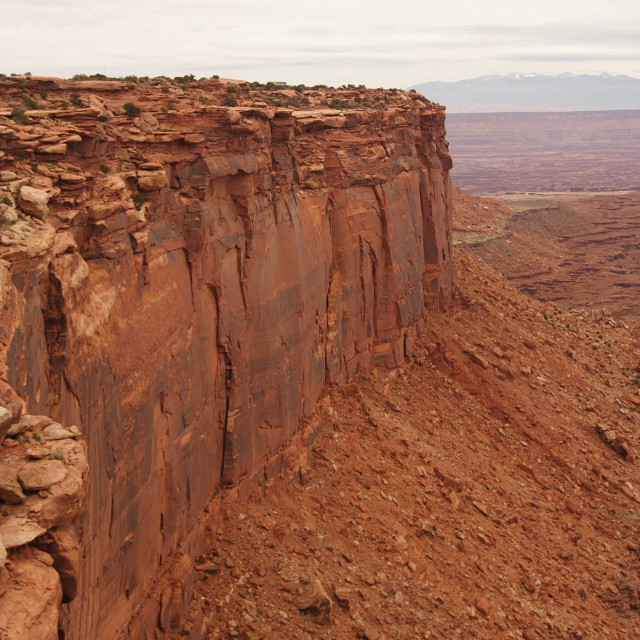
Grand view point rim walk - its a looong drop if you mistake a step..
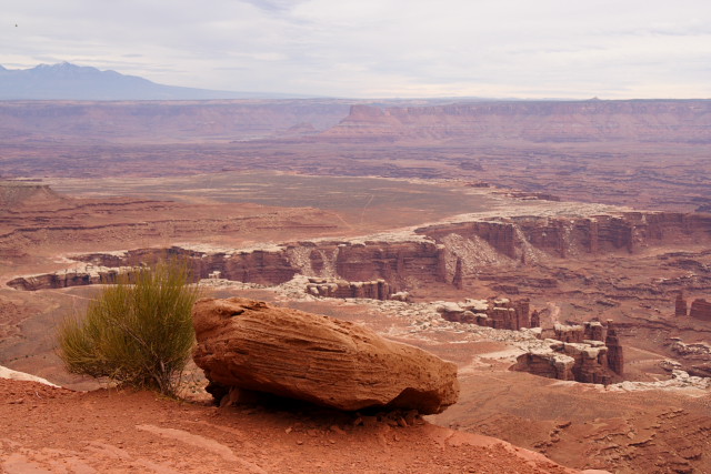
Another shot from Grand View rim walk
On wednesday my plan was to move to Bryce Canyon area - to the town of Panguitch. I took a scenic route (24 and then 12) and hit another canyon park - Capitol Reef. There the world is not just red but comes in all colors - especially in fall. I adjusted my plans a little and spent a few hours there.
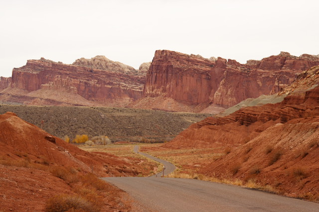
Scenic drive - Capitol Reef
I took a short hike to Hickman bridge and then cruised slowly on capitol reef scenic drive - again it was nice to have convertible..
November is very quiet time in the parks - only a few visitors and the picnic areas are empty so other guests may be seen (although I think those guys will be there in the middle of tourist season, too).
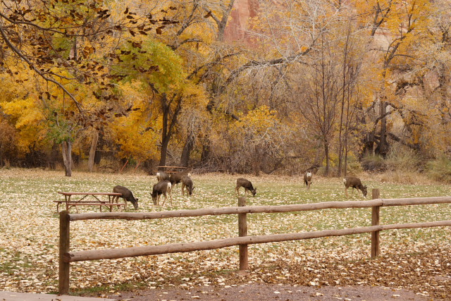
Picnic
Trying to describe those vistas in a web sized picture is again beyond my abilities, but if you can spot the car (RV) in the next picture then you may get the idea (hint: it's white and on the top..).
Grand view point rim walk - its a looong drop if you mistake a step..
Another shot from Grand View rim walk
On wednesday my plan was to move to Bryce Canyon area - to the town of Panguitch. I took a scenic route (24 and then 12) and hit another canyon park - Capitol Reef. There the world is not just red but comes in all colors - especially in fall. I adjusted my plans a little and spent a few hours there.
Scenic drive - Capitol Reef
I took a short hike to Hickman bridge and then cruised slowly on capitol reef scenic drive - again it was nice to have convertible..
November is very quiet time in the parks - only a few visitors and the picnic areas are empty so other guests may be seen (although I think those guys will be there in the middle of tourist season, too).
Picnic
Posted at 05:44 ap.
La - Marraskuu 12, 2005
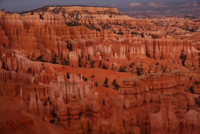
Bryce Canyon!
Spent a day in Bryce Canyon - one of the
strangest places I have ever been
My last canyon visit was Bryce - one of the best
canyon parks in Utah. Bryce is well known for it's "hoodoos" - brown, red,
orange, yellow, and white pinnacles of limestone, sandstone, and
mudstone.
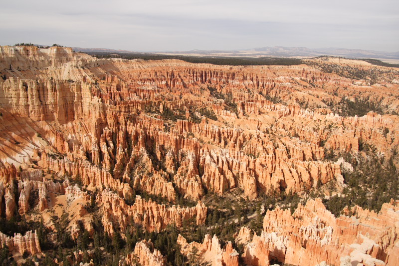
Bryce Canyon
I wanted to do some serious hiking and did Fairyland loop. The loop goes in to Fairyland and Campbell canyons for close look at the hoodoos. The hike is about 13 kilometers and has some 700m descending and climbing in altitudes between 2200m and 2500m.
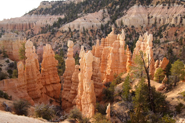
Hoodoos in Fairyland canyon
After I had recovered from Fairyland hike I took shorter (2.2Km) but very interesting "Navajo Loop" which descends 167m in the middle of giant hoodoos.
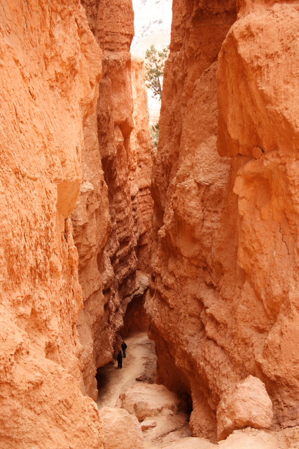
Wall Street
The day had been mostly cloudy but there was a small chance for a sunset so I went to sunset point and waited what would happen. The western sky cleared out just for the sunset but unfortunately the canyons open to the east so the setting sun could not reach the canyons anymore. The light show was still pretty nice.
Bryce Canyon in dusk colors
Enough red rocks for now - time to move on to arrive to California in time.
Bryce Canyon
I wanted to do some serious hiking and did Fairyland loop. The loop goes in to Fairyland and Campbell canyons for close look at the hoodoos. The hike is about 13 kilometers and has some 700m descending and climbing in altitudes between 2200m and 2500m.
Hoodoos in Fairyland canyon
After I had recovered from Fairyland hike I took shorter (2.2Km) but very interesting "Navajo Loop" which descends 167m in the middle of giant hoodoos.
Wall Street
The day had been mostly cloudy but there was a small chance for a sunset so I went to sunset point and waited what would happen. The western sky cleared out just for the sunset but unfortunately the canyons open to the east so the setting sun could not reach the canyons anymore. The light show was still pretty nice.
Bryce Canyon in dusk colors
Enough red rocks for now - time to move on to arrive to California in time.
Posted at 08:07 ap.
Su - Marraskuu 13, 2005
Nevada
Drove through Nevada..
After spending half a week in Utah I had only
three days to reach Milpitas, CA, so I did not plan much activities for Nevada
or California. On Friday, I drove through some *very* quiet roads (I think I
drove Utah route 21 for about 60 miles without seeing any other car) to town of
Baker and Great Basin National Park. The park itself was pretty much closed for
winter but they have interesting caves - Lehman caves, which made nice stop to
the boring driving.
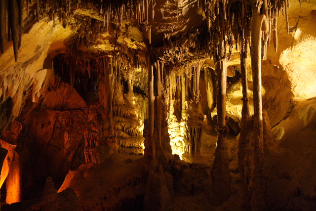
After cave visit I drove down to the town of Baker (population: ~100) and found one place which was open for lunch. Their food menu was not large but included a very good stew. The drink menu was then a surprise: about 20 different microbrews and small but well thought selection of single malts and cognacs. I had also the best coffee for many many years! The interior was home like and a silly mixture of different styles with bright colors - but it worked and brought a smile to my face. Only in America..
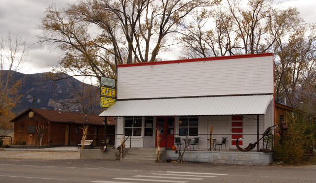
Silver Jack cafe in Baker
The next town was Ely where I stopped for refuel and visited a local railway museum. That was very interesting visit. An old railway station and the surrounding are was turned into a museum and an old employee gave me a 2-hour tour through the area and explained the history and current activities. Everything is based on volunteer work and they were restoring locomotives and cars and arrange tours now and then.
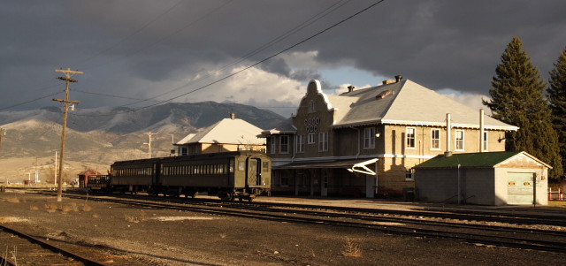
Ely station and museum
The tour included a visit to their workshop, which must be every boy's dream - imagine having a real steam locomotive to play with instead of a toy one..
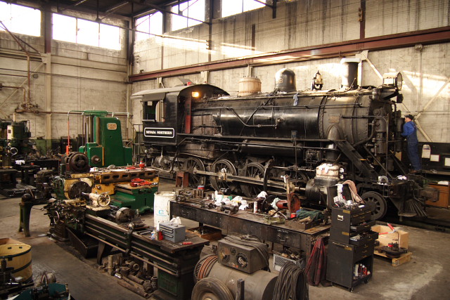
#93 getting some maintenance
Not a bad day, at all.
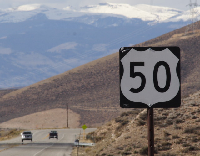
If I thought that Utah is empty place then Nevada must be from a different planet. Kilometer and kilometers empty roads and a small town every 100Km. The US-50 road first climbed over some hills, then there was 30Km straight road and another hill and another straight..
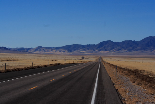
US-50 somewhere in Nevada
At least the road was quick to drive and I reached Carson City pretty quickly on saturday - Carson City was the first real town I visited since El Pueblo about week earlier.. It also ended my burger/sandwhich diet I had to suffer in the smaller towns. As it was only early afternoon I left Carson City and passed over Sierra mountains to California. US-50 is the road to Lake Tahoe - a popular weekend escape for californians. The South Lake Tahoe down is interesting as the California/Nevada state line goes through the town. The California side is like any well developed town for winter sports - small hotels, shops etc in wooden buildings. Right on the Nevada side of the state line are several 20 stories high Casinos - The town changes completely when you walk over the state line street!
There had been snowfall some time earlier in Lake Tahoe area but now the roads were dry and I cruised over Sierra mountains smoothly so I did not had to test how well the Mustang would go in snow conditions.
After cave visit I drove down to the town of Baker (population: ~100) and found one place which was open for lunch. Their food menu was not large but included a very good stew. The drink menu was then a surprise: about 20 different microbrews and small but well thought selection of single malts and cognacs. I had also the best coffee for many many years! The interior was home like and a silly mixture of different styles with bright colors - but it worked and brought a smile to my face. Only in America..
Silver Jack cafe in Baker
The next town was Ely where I stopped for refuel and visited a local railway museum. That was very interesting visit. An old railway station and the surrounding are was turned into a museum and an old employee gave me a 2-hour tour through the area and explained the history and current activities. Everything is based on volunteer work and they were restoring locomotives and cars and arrange tours now and then.
Ely station and museum
The tour included a visit to their workshop, which must be every boy's dream - imagine having a real steam locomotive to play with instead of a toy one..
#93 getting some maintenance
Not a bad day, at all.
If I thought that Utah is empty place then Nevada must be from a different planet. Kilometer and kilometers empty roads and a small town every 100Km. The US-50 road first climbed over some hills, then there was 30Km straight road and another hill and another straight..
US-50 somewhere in Nevada
At least the road was quick to drive and I reached Carson City pretty quickly on saturday - Carson City was the first real town I visited since El Pueblo about week earlier.. It also ended my burger/sandwhich diet I had to suffer in the smaller towns. As it was only early afternoon I left Carson City and passed over Sierra mountains to California. US-50 is the road to Lake Tahoe - a popular weekend escape for californians. The South Lake Tahoe down is interesting as the California/Nevada state line goes through the town. The California side is like any well developed town for winter sports - small hotels, shops etc in wooden buildings. Right on the Nevada side of the state line are several 20 stories high Casinos - The town changes completely when you walk over the state line street!
There had been snowfall some time earlier in Lake Tahoe area but now the roads were dry and I cruised over Sierra mountains smoothly so I did not had to test how well the Mustang would go in snow conditions.
Posted at 06:03 ap.
Ma - Marraskuu 14, 2005
The End
Arrived to California - end of vacation - start
of business
After and uneventful night in Placerville I
followed US-50 to it's endpoint in Sacramento. The road really did not end -
just changed to I-80 without too much notice. I followed I-80 for a few miles
and then turned back and noticed that at least there is a start-point for US-50,
though
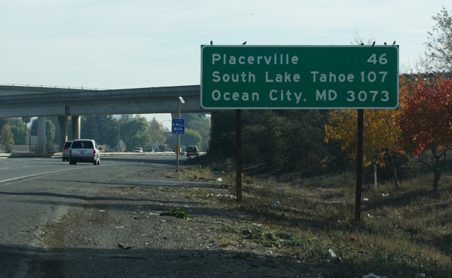
US-50 begins - 3073 miles to east cost
I did some extra side trips and drove about 4700 miles, though.
Before arriving to my hotel in Milpitas I stopped in Sacramento and walked around the old Sacramento area and visited the railway museum there. The museum was very nice but maybe too polished compared to the museum in Ely. The Sacramento museum has many more locomotives and cars on display but they are too shiny and surrounded with fancy lights and mirrors to look convincing. This one was outside of the main building in a constructed station area.
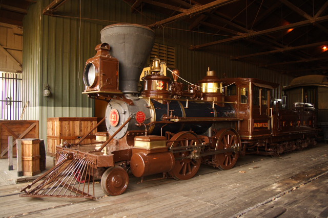
Locomotive in Sacramento railways museum
The next stop was Milpitas and end of vacation. I spend a few business days there but realized that I had not yet seen Pacific Ocean so I could not claim to had driven from coast to coast, yet. So after my work was done I took my car for one last drive and went over the mountains to see the Ocean.
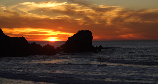
It was fun as long as it lasted.
US-50 begins - 3073 miles to east cost
I did some extra side trips and drove about 4700 miles, though.
Before arriving to my hotel in Milpitas I stopped in Sacramento and walked around the old Sacramento area and visited the railway museum there. The museum was very nice but maybe too polished compared to the museum in Ely. The Sacramento museum has many more locomotives and cars on display but they are too shiny and surrounded with fancy lights and mirrors to look convincing. This one was outside of the main building in a constructed station area.
Locomotive in Sacramento railways museum
The next stop was Milpitas and end of vacation. I spend a few business days there but realized that I had not yet seen Pacific Ocean so I could not claim to had driven from coast to coast, yet. So after my work was done I took my car for one last drive and went over the mountains to see the Ocean.
It was fun as long as it lasted.
Posted at 04:31 ap.
Calendar
| Su | Ma | Ti | Ke | To | Pe | La |
Categories
Archives
XML/RSS Feed
Statistics
Total entries in this blog:
Published On: joulu 04, 2005 07:21 ip.
Published On: joulu 04, 2005 07:21 ip.